Glenn Kirschner – Giuliani now in contempt of Congress, literally & figuratively. Will Congress use inherent contempt?
Meidas Touch on Twitter – Someone you love
Someone you love might need an abortion someday. Help ensure that when that day comes, they are able to get the care they need. Pass this video on and show your support. pic.twitter.com/iyjha2jfAJ
Experts in autocracies have pointed out that it is, unfortunately, easy to slip into normalizing the tyrant, hence it is important to hang on to outrage. These incidents which seem to call for the efforts of the Greek Furies (Erinyes) to come and deal with them will, I hope, help with that. As a reminder, though no one really knows how many there were supposed to be, the three names we have are Alecto, Megaera, and Tisiphone. These roughly translate as “unceasing,” “grudging,” and “vengeful destruction.”
The sight of industrialists stealing resources from indigenous peoples, and of that theft essentially turning into genocide, is unfortunately nothing new. It is as famiiar at Standing Rock as it is in the Amazon basin. But there’s a new twist to this story – the potential use of satellite techno;ogy and data to provide proof of injury – and of agency when the guilty parties deny fault. See what you think.
==============================================================
Satellites over the Amazon capture the choking of the ‘house of God’ by the Belo Monte Dam – they can help find solutions, too
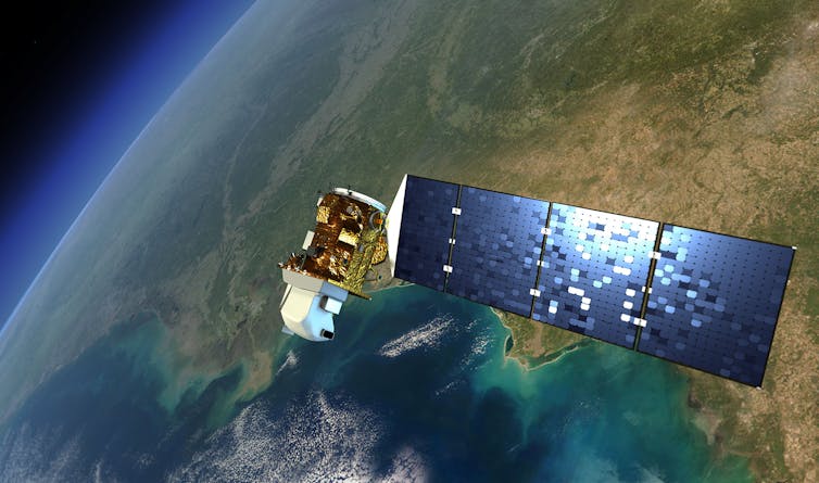
NASA’s Landsat satellites have been monitoring changes on Earth’s landscape for 50 years. NASA illustration
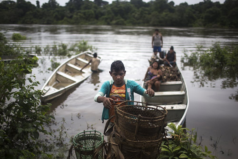
The Xingu River is revered as the “house of God” by the Indigenous people living along its Volte Grande, or Big Bend, in the Brazilian Amazon. The river is essential to their culture and religion, and a crucial source of fish, transportation and water for trees and plants.
Five years ago, the Big Bend was a broad river valley interwoven with river channels teaming with fish, turtles and other wildlife. Today, as much as 80% of the water flow is gone.
That’s because in late 2015, the massive Belo Monte Dam project began redirecting water from the Xingu River upstream from the Big Bend, channeling it through a canal to a giant new reservoir. The reservoir now powers one of the largest hydropower dams in the world, designed with enough capacity to power around 20 million households, though it has been producing far less.
Indigenous communities living in the Big Bend region of the Xingu River and its Bacaja tributary rely on the river for food and to transport crops. Taylor Weidman/LightRocket via Getty Images
Most of the river’s flow now bypasses the Big Bend, and the Indigenous peoples who live there are watching their livelihoods and way of life become endangered. Some of the most devastating effects are during the rainy season, when wildlife and trees rely heavily on having high water. The consortium of utilities and mining companies that runs the dam has pushed back on government orders to allow more water to reach the Big Bend, claiming it would cut their generation and profits. The group has argued in the past that there was no scientific proof that the change in water flow harmed fish or turtles.
There is proof of the Belo Monte Dam project’s impact on the Big Bend, though – from above. Satellite data shows how dramatically the dam has altered the hydrology of the river there.
The front satellite image shows the Big Bend of the Xingu River on May 26, 2000, before the Belo Monte Dam project began. Move the slider to the left to see the same region on July 20, 2017.
The same satellite data can also point to potential solutions and ways that operators of the Belo Monte Dam could revise the dam’s operations to keep both its renewable power and the Xingu River flowing at the most important times of the year.
As scientists who work with remote sensing, we believe satellite observations can empower populations around the world who face threats to their resources. The fact that satellite observations of surface water of the Xingu River can be clearly tied to the construction and operation of the Belo Monte Dam offers hope that this kind of knowledge can no longer be hidden.
50 years of Earth observation
Satellites have been monitoring changes in Earth’s landscapes for 50 years, ever since the U.S. launched the first Landsat satellite in July 1972. By piecing together data from the Landsat program and other satellites, scientists can reconstruct historical patterns of change in the landscape and predict current and future trends. They can monitor forest cover, drought, wildfire damage and desert expansion, as well as river flows and reservoir operations around the world.
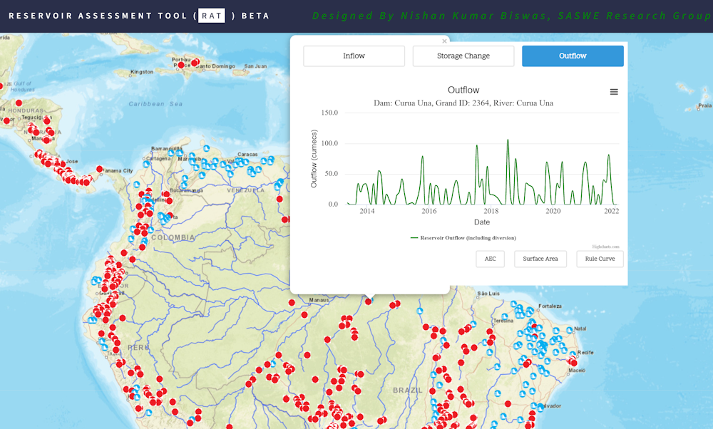
An example of how that data can be used to help threatened communities is the global Reservoir Assessment Tool, which was created by colleagues and one of us at the University of Washington. It monitors how much water is in about 1,600 reservoirs around the world.
The Reservoir Assessment Tool allows communities to track river flow changes caused by nearby dams and locate proposed dams. It currently tracks dams built before 2000. University of Washington
Dam operators already collect thorough on-site data about water flow, but their datasets are rarely shared with the public. Remote sensing doesn’t face the same restrictions. Making that data public can help hold operators to account for and protect local communities and their rivers.
How satellites could pressure Belo Monte to share
Satellite monitoring can provide unprecedented insight into the operations of dams like the Belo Monte and their impact on downstream populations.
Existing satellite data can be used to monitor recent historical behavior of a dam’s operations, track the state of the river and patterns of inflow and outflow at the dam, and even forecast the likely state of the reservoir. Much of that data is easily accessible and free. For example, a tool created for the regional governing body of the Mekong River Commission is empowering communities along the river in Southeast Asia by giving them access to satellite data about water flow at each dam – data that cannot be hidden or modified by those in power.
While estimates based on remote sensing have higher uncertainty than on-site measurements, unfettered access to such information can provide local populations with evidence to argue, in court if necessary, for more water releases.
Members of Indigenous groups living in the Big Bend region talk about changes they’ve seen since the dam was built.
Long-term observations of dams and hydroclimate records show it is possible to revise the standard operating procedures of dams so they allow more water to flow downstream when needed. A compromise with the Belo Monte Dam could ensure that enough water flows to the Xingu’s Big Bend region while also providing hydropower benefits.
By making the impact of the Belo Monte Dam and others like it public to the world, agencies and the general public can put pressure on the dam’s operators and its investors to release more water. Public pressure will become increasingly important, as water disputes in the Amazon are expected to worsen as the planet warms and deforestation continues. Climate change will affect river flow patterns in the Amazon and likely increase droughts, leaving less water during some periods.
Monitoring dams is a powerful way satellites can make a difference. Nearly two-thirds of Brazil’s electricity comes from more than 200 large and 400-plus small hydropower plants, and more large dams are expected to be built in the Amazon this decade. Many are in areas with Indigenous populations.
The Belo Monte Dam’s construction, shown here in 2012, flooded land and changed the river. Mario Tama/Getty Images
[Over 150,000 readers rely on The Conversation’s newsletters to understand the world.Sign up today.]
Remote sensing may not directly solve the problem of social injustice, but it offers the tools needed to recognize the problems and explore solutions. Being able to monitor changes in near-real time and compare them with historical operations can help maintain the checks and balances required for equitable growth.
Raaghul Senthilkumar, a former Master’s student at the University of Washington, contributed to this article.
============================================================== Alecto, Megaera, and Tisiphone, as the authors point out, satellite data is not a solution – it is only a tool – but it appears to me to be a darned good one. Put on your Eumenides hats, and stir up indigenous people and activists who care, and help them acquire and use this tool, with all other tools, to defend themselves. And, please – without delay. Our environmentsal losses, cultural losses, human losses have been so severe already, largely through delay, that we really cannot afford any more.
Glenn Kirschner – Draft opinion shows Supreme Court about to revoke women’s constitutional privacy rights
Meidas Touch – Texas Paul REACTS to Supreme Court Justices Lying UNDER OATH!
Rebel HQ – Ojeda v. Gaetz
Really American – GOP Plans To Take Right to Privacy (It’s been suggested that future movemets for abortion [and birth control] should not focus on the 14th Amendment but on the 13th, which prohibits involuntary servitude, and I concur.)
Glenn Kirschner – Georgia special grand jury investigating Trump’s election crimes AND Lindsey Graham & Rudy as well
Meidas Touch – Texas Paul REACTS to Leaked Abortion Decision
The Lincln Project – Last Week in the Republican Party
MSNBC – Sen. Whitehouse Joins The Last Word with Lawrence O’Donnell to Talk Ethics at the Supreme Court (There’s a reason why “borked” now mwans “screwed.”)
The Late Show – The Supreme Court Doesn’t Give A Damn What The Public Wants | How Gullible Is Susan Collins? (Yes, it’s long, but it’s Colbert – it flies by)
Mrs Betty Bowers – Stupidest People in Congress Awards